It was dusk. I needed to pick blueberries for the bannock. It was the end of the first day of a two-day trip back to base camp. A two-day journey canoeing across lakes, rivers and rapids, navigating portages and driving 100+ km on a logging road (avoiding the 14-wheelers driving like bats out of hell) and five hours on the TransCanada Highway.
We were searching for rock-art (pictographs and petroglyphs) and habitation sites in the Brightsands River system, part of a vast web of river systems stretching as far as the Arctic Ocean to our North, the exploration routes from the fur-trade era. Often viewed from the south as a mosquito-laden swamp, good for nothing good for furs, the Canadian Shield is a vast granitic mass covered in forest - a lung of the planet. It took the railway to exploit its enormous potential for timber, diamonds and metals.
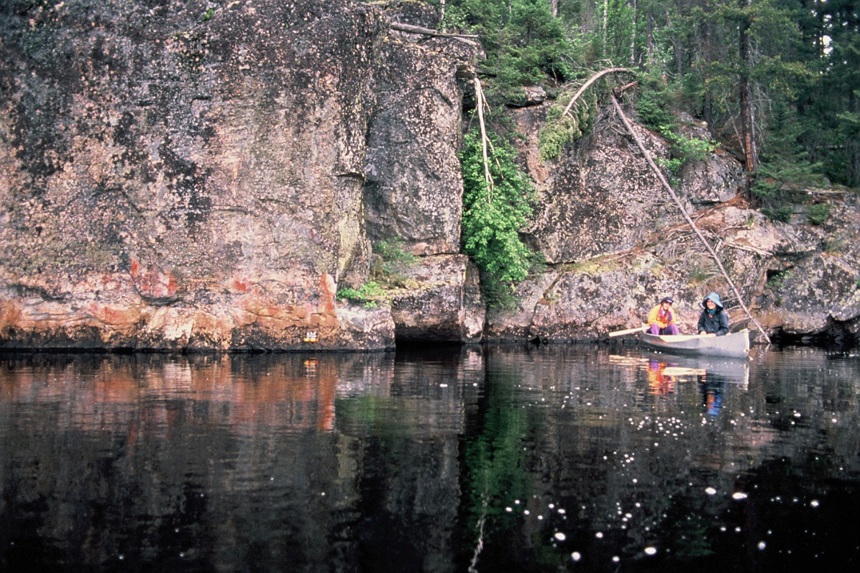
Our crew of archaeologists were the latest in a procession of specialists sent to examine the landscape. Our task was to ascertain the range, type and location of any archaeological sites, as the land was designated to join a Provincial Park - the latest phase of Canadian governments’ attempts to make an impact. We were endeavouring to understand the landscape travelling by canoe, running or lining the rapids and portaging to avoid waterfalls. We were recording, assessing and photographing each pictograph, site noting their geographical coordinates.
Each trip we were canoeing further ‘into the bush’. Our travel time, initially measured in hours, now meant days on the Brightsands River system. Today we had stopped at around 6pm following a 9am start. We had used this locale on our way ‘in’ 20 days earlier. We were tired, hungry, low on supplies and racing to meet our boss in town at an agreed deadline of 8pm tomorrow. The hot topic was the menu for the ‘real’ meal in town.
'Often viewed from the south as a mosquito-laden swamp, good for nothing good for furs, the Canadian Shield is a vast granitic mass covered in forest - a lung of the planet. It took the railway to exploit its enormous potential for timber, diamonds and metals.'
This evening I was the designated blueberry picker, after I’d set up a new camp on the river bank. The berries were vital: they would eke out the remainder of the flour for making bannock that evening on a grill over the fire coals, after we had radioed the closest government operator to let our boss, the Regional Archaeologist, know we were safe. Two colleagues were chopping wood for the campfire. Bob, a self-described ‘brick shit house’ in charge of unpacking for the night and cooking dinner, said he would join me gathering berries after his tasks were complete.
I pitched my tent, put my backpack inside, zipped up the sleeve, grabbed a bucket and walked into the bush behind the tent. Jackpines and deciduous trees grew a few metres from our kitchen and campfire. They obscured some low-lying bushes, the first stage of plant growth after a forest fire a few years before: a strong sign of ripe blueberries, providing the bears hadn’t got there already.
I squeezed my way between the trees and I realised that I’d hit paydirt! Dusk was falling, but now I didn’t care. I leaned over the berry bushes which reached my knees and just picked, forgetting time. The familiar loud sound of the berry hitting the bottom of the metal bucket ceased as it filled. As the sun fell below the horizon I depended on my fingers to find the berries between the leaves. I wasn’t worried in the darkness. All chores were divided into six: unpacking heavily laden canoes filled with our clothes, tents, ropes, kitchen equipment, food (including a metal cooler) and archaeology field and photographic equipment.
'As the sun fell below the horizon I depended on my fingers to find the berries between the leaves. I wasn’t worried in the darkness.'
The Canadian wilderness (photo by Hendrik-Cornelissen, Unsplash).

Bob had turned up, a large amorphous shape picking berries beside me. I concentrated on picking berries, now and again commenting on their juiciness as they burst in my fingers. Bob didn’t reply. I figured that he was tired, and he wasn’t very talkative. It had been a very long day. I just heard his breathing. He moved away from the campfire and deeper into the large berry patch I had noticed earlier.
Light was fading fast and soon it was dark, the moon above the treeline. My bucket felt full. “I’ll see you back at the campfire I called out to Bob. I turned around and walked towards the campfire, barely visible. Everyone was talking loudly, preparing for dinner with the pots in the coals, cooking the remainder of the pasta and the last tin of tomatoes. Puzzled, I saw Bob. “Oh, that was fast of you!” he said.
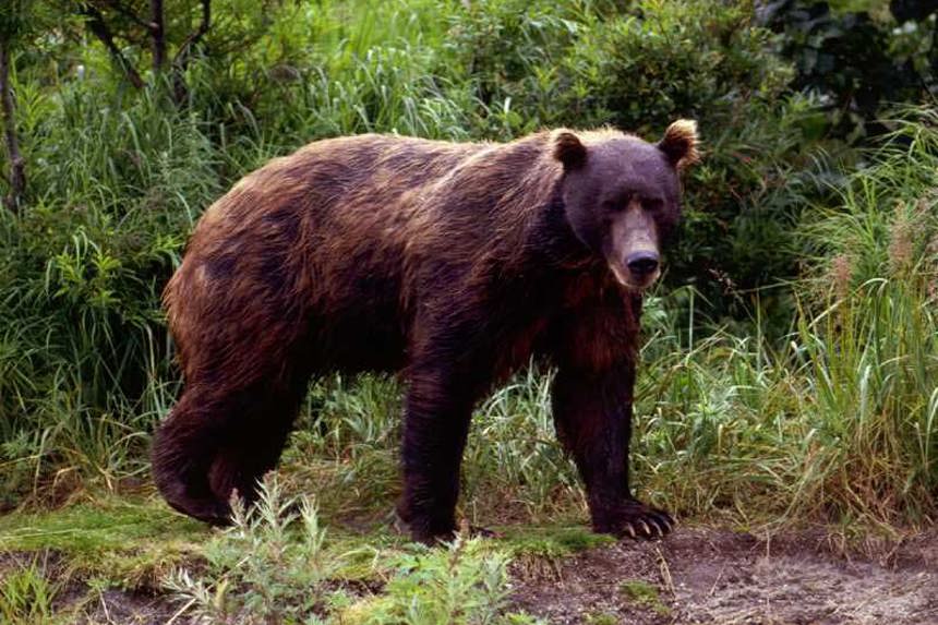
He hadn’t followed me … it was a bear! No wonder he didn’t reply.
A brown bear.
What is the point of my tale?
The label ‘the bush’ is deceptive as vast forest is a wilderness. The ‘Boreal Zone’, the subarctic, is another Amazon. It is a rich mix of landscapes: dense spruce forest, open bogs, lichen woodlands, tundra-covered ridge tops, alpine tundra, river valleys, hundreds of lakes of every size imaginable, heathlands in regions influenced by the ocean and grasslands in drier areas. These landscapes contain vast forest, plant and faunal populations.
To work, live and explore the Boreal Zone requires a high level of technical skill, intra-group cooperation, self-reliance and understanding of the physical environment in all its complexity. Survival with any success requires a comprehensive understanding of the seasons and their impact on ecology, water transportation, dramatic extremes of temperature and a host of hidden risks and opportunities.
Survival anywhere, but especially in the subarctic of northern Canada, also depends on recognition of the validity of the Other. Understanding this region entails understanding its deep past, its recent past and its present. The activities of the Indigenous peoples and the activities of successive governments have affected its topography. Indigenous peoples and new settlers from Europe and the south live in uneasy coexistence, continuously reshaping this vast region.
Despite its portrayal by Ontario Parks (the provincial park system for Ontario), the landscape has never been ‘empty’. Indigenous peoples have lived here for millennia. Fur traders, from the mid-17th century onwards, followed ‘explorers’ using routes suggested by their guides, the Indigenous peoples. As the fur trade spanned out, they were followed by peoples of both French and Scottish origins: hardscrabble settlers who wrested a living from poor soils.
Alicia on an archeology expedition.
By Confederation in 1867, Indigenous peoples were seen as part of a colonial project whereby the landscape was reimagined as one from which they were excluded, illegitimate spectres with a singular identity. Strange, since Indigenous peoples are distinct. As curators of the forest, their activities are in plain sight. Settlers viewed the region as relatively remote from the great cities to the south and east. It is The North: a blank slate to be subdued in heroic fashion. As an untouched ‘wilderness', the Indigenous landscapes could be erased and cleared for white settlement. The legal concept Terra nullius, thankfully now defunct, provided a cover for these colonial activities.
When the Park system was devised in the late 19th and early 20th century, the settlers saw the Boreal Forest as stark, unforgiving, remote and pristine - lacking the ‘civilization' of the cities. Taming it entailed the construction of a capital-intensive infrastructure. From the late 19th century settlers built dams and roads, developed the extractive industries of mining, logging and commercial fishing and created parks and built ‘cottages'. Settlers changed the landscape, irrevocably.
Outside Canada this landscape is visible in the iconic paintings by the Group of Seven, a group of white Canadian artists active from 1920 to 1933 and depicted as quintessentially Canadian. Northern Ontario’s landscapes became beacons amongst the Group’s works. The Group achieved a sense of the brute power of that raw landscape by painting images devoid of farmers, Indigenous people or industry. Captured through vivid colours applied with careful brushstrokes, their works are considered depictions of Ontario’s natural landscapes.
'Settlers viewed the region as relatively remote from the great cities to the south and east. It is The North: a blank slate to be subdued in heroic fashion. As an untouched ‘wilderness', the Indigenous landscapes could be erased and cleared for white settlement.'
Today's obsession with identity leads us to emphasise attachments to specific landscapes and regions, which challenges us all to speak of the evidence of colonial rule, greed and brutality. While all identities are global, these are seen as uniquely Canadian. They are symbols of the autonomy and independence wrested from the British Government in 1867, of Canada’s deep connection, dating from Jacobean Scotland, Elizabethan England and France of the ‘Sun King' Louis XIV.
The Group of Seven helped create an extraordinarily powerful identity for Canadians, one distinct from their European ancestors. By the 1920s Canada had emerged, its fighting forces honed by the sheer savagery of industrialised warfare - the heroics displayed on Vimy Ridge and the bloody endurance of the squalor of the trenches of the Western Front. These landscape paintings confirmed the Northern wilderness as a source of identity and vigour for an emerging nation.
The official vision of Canada's past as a ‘settler colony' assumes the appropriation of Indigenous land. This raises an important question: To what extent does Canada's official identity depend on the cultural politics of erasure, exclusion and appropriation? The Boreal Forest cannot be ‘industrial’ and ‘pristine’. The largest inflow of settlers arrived after 1870, when Social Darwinism - ‘survival of the fittest’ - provided a framework to legitimise their activities. In that Gilded Age, the North was to be ‘tamed' for ‘civilisation'. The fate of ‘inferior peoples’ was seen as the cost of doing business.
For settlers, the Boreal Forest was the site of a heroic struggle between ‘progress' and ‘tradition'. That view was wildly popular, written up by the scholars, who accompanied the railroad: their lens grounded by time spent at universities. Those paintings on the granite outcrops were labelled ‘Rock Art', their stark images the products of ‘unreason' - to be ogled at, but saying nothing about ‘progress'. They did not speak to the zeitgeist.
The Group of Seven ignored evidence of human involvement which was often in plain sight. The landscapes became iconic, to be preserved as Parks. Wilderness was to be experienced free from Indigenous folk. Writing in the 1930s, contemporaries of the Group such as Harold Innis developed the Laurentian Thesis to explain the extractive, resource-centred economic forces associated with Canada’s coming of age in the 1920s.
But these iconic landscapes house the pictograph sites which bear mute witness to other, far older traditions - ones depicted on the sheer granite cliff faces. These pictographs are stark reminders of the centuries-old medicinal practices (plant-based medicine), religious beliefs, visual expressions and the assiduous record keeping of the Algonquian speaking peoples. When included in the archaeological record, they occupy a void in the narrative of an imaginary settler’s North. They aren't 'art' in the Western sense … they cannot be bought and sold. They do, however, occupy our minds.
Expeditions are research; they are adventures of the mind. Interpretation involves meditation on the entire landscape, the complexity of prior land use, the physical geography and the challenges faced initially by explorers and subsequently by wave after wave of colonists, displacing Indigenous occupants. This requires immersion in the physical context of each archaeological site, but an expedition is not just a physical challenge. Research is exploration not just of the colonial and Indigenous soul of a place, but its successive identities. Exploration morphs.
The bear, peacefully gathering berries, had much to tell me: that we could share, and live together. We accepted each other. Otherwise I might not be here to tell the tale.


